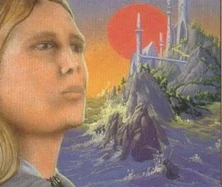
Vision of Tol Eresseä
Tol Eresseä was a green and beautiful large island near to the shores of Aman and within the Bay of Eldamar, inhabited largely by Noldo Elves; it was, usually, the first land sighted by ships sailing to the Undying Lands.
Other Names:
- Albion
- For Faidwen
- The Island Ferry
- Leithian
- the Lonely Island
- Luthany
- Lúthien
- se uncútha holm
Regions[]
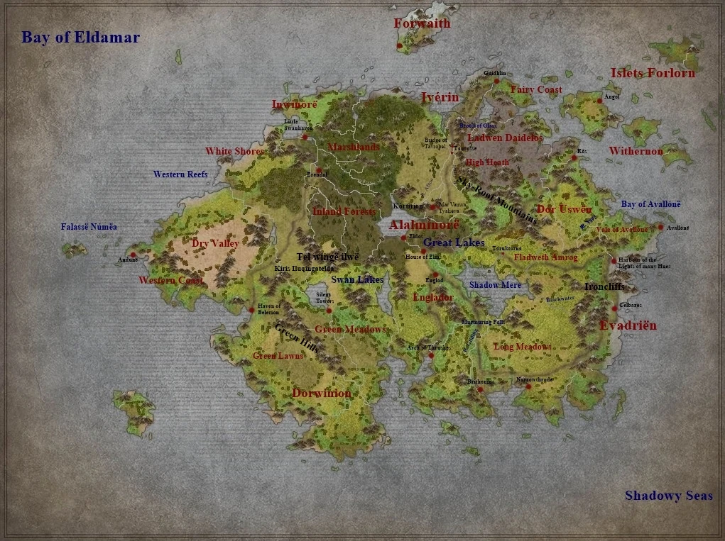
Tol Eresseä in the Sixth Age
Afros Vales Alalminórë Avon Blackwater Brook of Glass For Faedwen Dor Uswen Dorwinion Dry Valley Eldaros Englad Englador Engriol Erenol Evadrien Fairy Coast Falasse Númea Fladweth Amrog Forlorn Islets Forwaith Gar Lossion Great Lake Green Hills Green Lawn Green Meadows Gruir Vales Gruir Heath of the Sky-roof Hill of Kôr Ingilnore Inland Forests Inwinórë Iron Cliffs Iverin Kiris Iluqingatelda Kúne Malle Long Meadows Marshlands Path of Hazel Pómelaire River Gliding Shadow Mere Sky-roof Mountains Swan Lakes Taurosse Teamalle Teld Quing Ilon Tol Thúle Valley of Avallóne Western Coast Western Reefs White Shore Whitered Heath Tol Withernon Yarë River
Settlements and Places of Interest[]
Andúnë Angol Arch of Thrushes Avallónë Belerion Bridge of Tathrobel Brithonín Celbaros Cottage of Lost Play Cottage of the Children Eldos Erendol Estirin Gondobar Guidhlin Harbour of the Lights of many Hues House of Elms House of the Hundred Chimneys House of Memory Korin Korin of Meril-i-Turinqi Koromas Kortirion Mindon Gwar Narrowthrode Ros Silent Towers Silvalelya Swanhaven Taruhtarna Tatya Túna Tathrobel Taxóra Tirin
Inhabitants[]
Ailios Aranwë Arminas of the Falas Ausir Eltas Elwen of Tol Eresseä Eriol Evromord Galdor Gelmir Gilfanon Guilin of Nargothrond Heorrenda Ilfrin Ingwion Legolas of Gondolin Lindo son of Valwë Meril-i-Turinqi Naimi Pengolodh Quennar i Onótimo Rúmil of Tirion Salmar Timpinen Tulkastor Vairë of Tol Eressëa Valwë Veanne Voronwë Aranwion
Groups[]
Wise of Eressëa
Peoples[]
Ainur: Skyfolk Merfolk Nandini Nermir Orossi Tavari
Elves: Falmari Noldor Sindar Vanyar
Creatures[]
Bats Beetles Blackbird Butterflies Chequered Fish Cormorants Crows Dolphins Doves Eider-Ducks Elven-Birds Elven Horses Falcons Fishes Ghost-moths Golden Bees Great Eagles Great Glow-worms Great Gulls Great Swans Gunnets Mice Nightingales Noble Hounds Peacocks Petrels Pigeons Puffins Rock-doves Roe Deer Sea mews Shells Thrushes Whales Whitebirds
Plants[]
Apple-tree Bellflower Blue Nemophila Cress Elanor Elms Elvish Harebell Fir Golden Creepers Golden Asphodels Gwingyrn Hazel-tree Hollyhocks Houseleek Jacinth Lairelosse Larkspur Lavaralda Laurinque Lissuin Mallorn Maples Marigold Moss Mustard Nessamelda Great Oaks Oiolaire Phlox Pines Pinks plumed thistle plumed Weed Poplar Poppies Red Creepers Red Daisies Redthorn Reeds Sorrel súriquessë Taniquelasse Vardarianna White Lilac White Trees Willows Wine Yavannamire Yellow Daisy Yews
Notes[]
In the "Book of Lost Tales" Tolkien speculated that Iverin, the eastern part of Tol Eressea eventually broke off the main Island and later became Ireland (and possibly Great Britain).This indicates that Tol Eressea must have a considerable size, maybe comparable to New Guinea, Borneo or Sumatra.He later abandoned the concept and had Aelfwine return to Britain after his visit on Tol Eressëa, making them two entirely different islands. Some later Fan-on Authors however have revived or built up on the older idea, for example Author Jeff J. Erwin, writer of the Lindon Gazetteer, used the name Iverin for a part of Lindon suggesting that a part of Lindon later became Ireland and some of the lands east of Lindon, including the Shire, became the british isles.This was taken in consideration for the placing of toponyms on the new map.Placenames corresponding to toponyms of southwestern Britain generally were placed in southeastern Eresseä to suggest a possible ancient connection between the two landmasses.
Most maps show tol Eressea as lying on the girdle of Arda, however, taking into mind that JRR Tolkien envisioned the climate of Tol Eressea as similar to the british isles, this position seems unlikely.If the Bay of Eldamar lay on the equator, it must have been a far larger bay than widely depicted and Tol Eressea must have been located in it's northern reaches rather than directly in the tropical zones.
Notes[]
The employed map is for the greatest part based on Professor Tolkiens raw sketches published in The Shaping of Middle-Earth although several other maps and interpretations found on the internet were drawn from as inspiration as well.
References[]
- merp.com wiki