| Boromir: "Is it not a strange fate that we should suffer so much fear and doubt for so small a thing? So small a thing!" - J. R. R. Tolkien, The Fellowship of the Ring II:10 |
- Length: 625 miles, from Mellainende in the west to Mindolluin in the east
- Elevation: average peak elevation: 10,000-11.(XXX) feet; lowest peak: Ferendil (S. "Beech's Haven") 4.150 feet; highest peak: Lancrast (S. "Stark-horn") 13.804 feet
- Climate: average annual precipitation: 50-70 inches; mean annual temperature: 40-60°F; average low: Ninui 15°F; average high: Urui 85°F
- Composition: The White Mountains, like the Misty Mountains to the north, were composed primarily of sedimentary and metamorphic rocks, particularly limestone. Large quantities of marble at the eastern end of the range provided the Gondorians with an excellent building material. West of Calmirie, near the highest peaks of the range, there were some significant igneous intrusions. Iron, zinc, copper, and silver were mined by the Men of Gondor, and some prospectors had discovered small amounts of gold in the mountains of Anfalas.
- Notes: The Ered Nimrais probably appeared at about the same time Melkor raised the Hithaeglir. The ruin of Beleriand pushed these lofty peaks even higher. The highest mountains had snow caps throughout the year, but most of the peaks were bare from the spring through the autumn. Trees could be found quite high up the slopes, over 9,500 feet at the western end of the range. Many Gondorian mines cut into the flanks of the White Mountains, taking advantage of the natural caverns found there. Popular stories maintained that small tribes of Giants and Drúedain still lived in the hidden valleys of the White Mountains, yet no proof existed.
The Mountains were composed primarily of sedimentary and metamorphic rocks, subject to subterranean erosion and the evolution of numerous cave systems. Many of these caverns possessed beautiful limestone formations, and were often extensive enough to provide refuge for people in times of war. This capacity was first evidenced by the emergence of the highland Daen Coentis alliance in the early centuries of the Second Age, especially in their delving of Lugh Gobha under the tutelage of Sauron. Large quantities of marble at the eastern end of the White Mountains provided the folk of northern Gondor with excellent building material for the cities of Minas Anor and Osgiliath. West of the Mornan, near the highest peaks of the range, the hills of the Pinnath Gelin possessed some significant intrusions of volcanic origin, but the majority of southern Gondor’s inhabitants made use of the limestone and granite of the main mountain range for their buildings, using the many waterways of the realm to transport such materials to the coastlands.
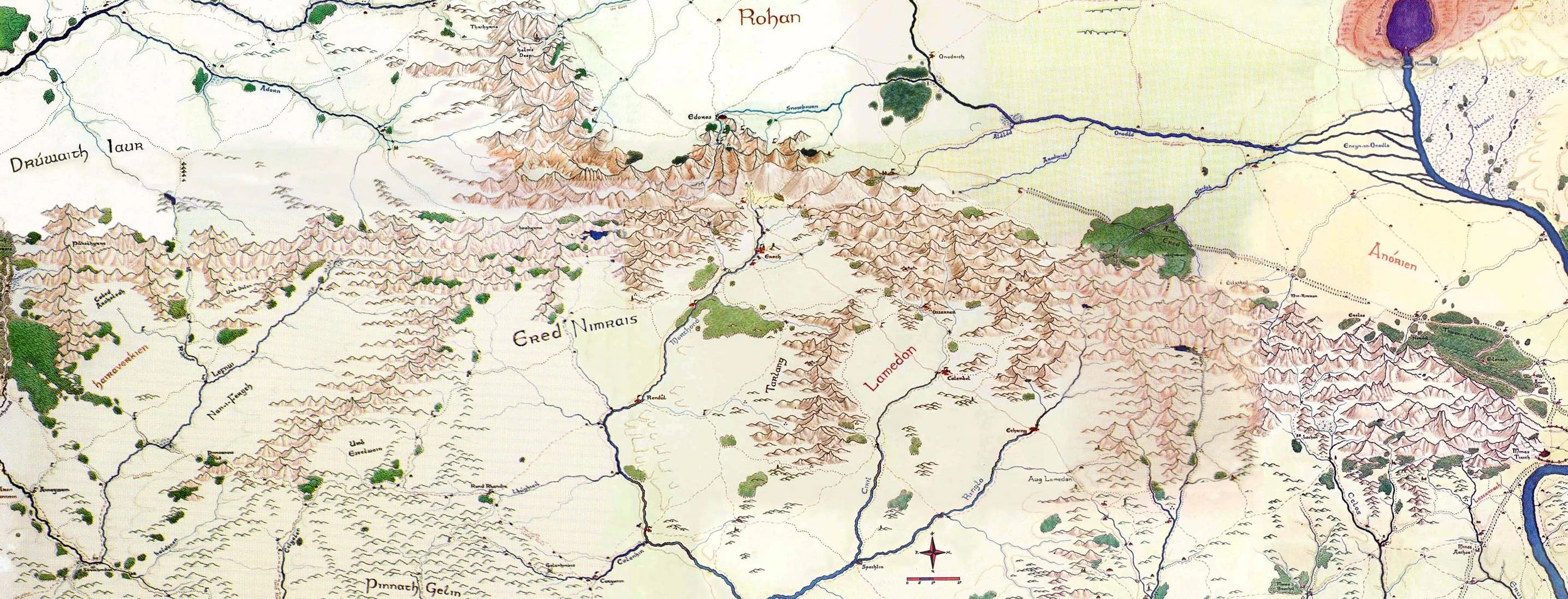
The Range ran for more than six hundred miles from east to west, from one end of southern Gondor to the other, dividing its lands from the northern half of the realm. To the west its peaks formed the Cape of Andrast, while to the east they halted before the path of the mighty Anduin as it made its way to the sea. The southern face of the White Mountains was more gradual and less steep than its northern counterpart, making extensive settlement of the mountain vales both possible and desirable. Also, unlike the northern slopes, the southern course of the mountains was interrupted at several points by outlying ranges — the Ered Torthonion, the Tarlang, and the Pinnath Gelin — which divided the lands of southern Gondor into distinct regions. Passes and gaps pierced both the outliers and the main range, facilitating travel from one end of the realm to the other. The two most important of these were the Cirith Dudhrandir and the Din-Lamedon, which breached the wall of the Ered Torthonion. The ancient Daen Coentis stronghold of Lugh Gobha remained the one true road through the White Mountains themselves, though its subsequent haunting by the Dead prevented its use by the living (much to the disappointment of travelers who would like nothing better than to enjoy a year-round passage connecting northern and southern Gondor at the very center of the mountain barrier).
Other names[]
Ered Nimrais (S: White-horn Mountains), Mountains of Gondor
Regions and Rivers[]
Adorn Anórien Celos Ciril Deeping-coomb Deeping Stream Drúadan Forest Dunharrow Entwash Vale Erui Gilrain Glanhir (Mering Stream) Imloth Melui Lamedon Lefnui Lossarnach Losseithel (Snowbourn) Morthond Morthond Vale Ringló Ringló Vale Serni Sirith Stonewain Valley Tumladen (Gondor) Valley of the Nightblades
Places[]
Aglarond Amon Dín Angthram (Irensaga) Beacon Hills Calenhad Dark Door Edoras Eilenach Erech Erelas Firienfeld Firienholt Halifirien Lancrast (Starkhorn) Mellainendë Minas Anor (Minas Tirith) Mindolluin Min-Rimmon Nardol Nardol Quarry Neledhras (Thrihyrne) Orod Faeren (Dwimorberg) Paths of the Dead Stone of Erech Tarlang´s Neck Thergor's Hideout
Peoples[]
Characters[]
Gundash Render Ripper Thergor the Starseer
References[]
- MERP: Riders of Rohan
- MERP: Southern Gondor The Land